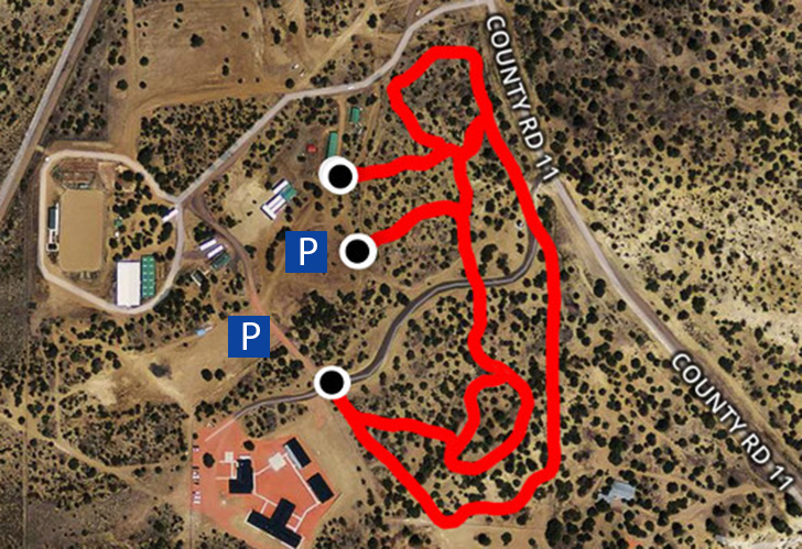
Fisher community Trail

A lightning storm from the Fisher trail head.

A lightning storm from the Fisher trail head.

Distance: 1.8 miles   

Difficulty: Moderate to difficult   

The Fisher Trail provides a beautiful location for walkers who want a wilderness experience within walking distance of the center of Cuba. It begins at a parking area on the Cubita Road 1 mile north of the NM 197 junction. The trail follows contours of the side of a tree covered mesa uphill and downhill until it crosses a large arroyo. It then climbs to a ridge that leads to the nearest corner of Santa Fe National Forest. Cairns (large rock pile markers) end at this point. Ambitious hikers can continue through a break in the cliff to the top of Cuba Mesa. The trail crosses from pinon~juniper woodland to ponderosa-oak forest and provides striking views of sandstone cliffs, the Nacimiento Mountains and the Village of Cuba. Wildlife sightings are frequent here. Bring water.


Rito san jose trail

Cubita Road separates the Rito San Jose and Fisher Trails.

Cubita Road separates the Rito San Jose and Fisher Trails.

RSJTrail.jpg
1485375643048.gif

Distance: 1.0 mile   

Difficulty: Easy to moderate    

The Rito San Jose Trail provides a nice location for walkers who want a natural river terrace experience within walking distance of the center of Cuba. It begins at a parking area on the Cubita Road 1 mile north of the NM 197 junction and across from the Fisher Community Trail parking area. The trail runs east over a sage covered flat across a small drainage and then to the rim of a small canyon. Hikers can continue down a slope to a figure-of-eight loop along the willow-covered river terrace. The trail provides beautiful views of Cuba Mesa and the Nacimiento Mountains. The river terrace is a great place for early morning and late afternoon birdwatching. Bring water and a snack.

St. Francis of assisi park trail

Sunrise at St. Francis of Assisi Park. 

Sunrise at St. Francis of Assisi Park. 

Difficulty: Easy

Distance: 1.0 mile

The trail circles the outside of the park along NM Highway 126, County Road 13 (to Cuba Schools) and the fenced north and west sides. Parking is available at the Eichwald Recreation Center and playground. Volunteers have planted new trees, shrubs and flowers, and placed boulders on the east and west sides of the park as well as a fence break at the northwest corner. There are benches at a kiosk at the southwest corner with information about the Continental Divide Trail and other walking activities. Nearby Destinations: Cuba Visitor Center, Cuba Schools, Catholic Church, Jemez Mountain Electric Cooperative Office, El Bruno’s Restaurant, Presciliano’s Restaurant, Subway.

Library Loop Trail

View of the sunrise over the Nacimiento Mountains from the Library Loop Trail.

View of the sunrise over the Nacimiento Mountains from the Library Loop Trail.

Distance: 0.5 mile

Difficulty: Easy

This trail begins at the entrance of the Cuba Library and circles open land to the south of the Library and behind the village housing. You can stay on the outside of the fenced Village property or cut across the property about halfway to shorten the walk. There is a bench with shade on the east side of the trail. There are beautiful views of the Nacimiento Mountains and Cuba Mesa. Nearby Destinations: Village Office/Senior Center, Village Housing, Cuba Library, Dialysis Center, Police Offices.


South U.S. 550 Sidewalks

View of a sunset summer storm on the Nacimiento Mountains from Cuba.

View of a sunset summer storm on the Nacimiento Mountains from Cuba.

Distance: 0.6 mile

Difficulty: Easy

The new sidewalk is four feet wide, smooth, set back from the curb, and has handicap access ramps from Cordova Ave.(Nacimiento Community Foundation/Public Health Office) to just above the NM Highway 197 Junction. You can cross US 550 carefully at either end to make a loop or walk back forth on once side. There are beautiful open views of the Nacimiento Mountains and Cuba Mesa from both sides of the road. Nearby Destinations: Dollar Store, Public Health Office, Cuba Health Center, Cuba Credit Union, Magistrate Court, Baptist Church, Power Saw Shop, Cuban Cafe, Forest Service Office.

Cuba schools cross country trails

A break in the storm on the Cuba Schools Cross Country Trails. 

A break in the storm on the Cuba Schools Cross Country Trails. 

Map-5 Webcropped.jpeg

Distance: 0.25-5 miles

Difficulty: Easy to  moderately difficult

The network of school cross-country trails provides many options for a short or more extended walk or hike. These trails can be entered at all hours from the access points shown. Paved parking is located outside the school fence as indicated. Loops of 0.5 miles (green line), 1.8 miles (orange line), 2.5 miles (black line) are signed. There are many lovely pinon, juniper, ponderosa and oak trees. There are beautiful views of the Nacimiento Mountains, Cuba Mesa and nearby sandstone cliffs. Bring water and a snack for extended hikes.


School Overlook Trail

An incredible view from the School Overlook Trail.

An incredible view from the School Overlook Trail.

static1.squarespace-1.jpg
static1.squarespace.gif

Distance: 0.5 mile

Difficulty: Easy to moderate

The network of school cross-country trails provides access to a spur trail on BLM land that leads to a scenic overlook of the Cuba valley. The entrance to the trail can be found along the green loop near the northeast corner of the cross country trails network. Look along the fence line for the v-gate entrance to the trail. The trail leads you across some small arroyos and up a sandstone ridge to a high point where there are beautiful views of the Nacimiento Mountains, Cuba Mesa and nearby sandstone cliffs. Bring water and a snack for extended hikes.

Sandoval county Fairgrounds trails

Sunset behind Cuba mesa

Sunset behind Cuba mesa

Distance: .25-1.25 miles

Difficulty: Easy to moderate

The network of Sandoval County Fairgounds trails provides many options for a short or more extended walk or hike. These trails can be entered during daytime fairgrounds times, which can vary by season. There is no entry fee except during the annual fair, Thursday - Sunday the first week of August. Parking and access points are located outside the Sandoval County Fairgrounds Community Center as indicated. The trail loops through piñon-juniper woodland and affords many beautiful views of Cuba Mesa to the west. Bring water.

Continental Divide Trail North

Cuba Mesa along the Continental Divide National Scenic Trail. 

Cuba Mesa along the Continental Divide National Scenic Trail. 

Map-8 web.jpg

Distance: 6.2 miles

Difficulty: Moderate to difficult

The Continental Divide Trail North/Los Pinos Trail climbs through Santa Fe National Forest from the Nacimiento Mountain foothills to the top of the mountains in the San Pedro Parks wilderness. It begins 6 miles northeast of Cuba at the end of Forest Road #95 where a parking area and kiosk are located. The trail follows the Rito Los Pinos for 3.1 miles and ascends almost 2000 vertical feet. It continues gently uphill and is shady along its entire course. Once on top of the mountain you can turn around, follow it several more miles to the center of the San Pedro Parks, choose a number of loop trails, or walk 2700 miles to the Canadian Border. Vegetation along the trail is lush and amazingly diverse. Views are limited until you reach the top of the mountain. Water in the Rito Los Pinos must be filtered and/or treated. Bring adequate water and food for the length of your planned hike. *** Directions provided in the link above take you to Forest Road #95, please follow to end of the road to find the trail head***

Continental Divide Trail South

CDTSouth.jpg
dogs-allowed.jpg

Distance: 7.0 miles

Difficulty: Moderate to difficult

The Continental Divide Trail South begins 4 miles southwest of Cuba on a dirt road that runs south from mile marker 4 on NM 197. It follows the roadway approximately 1 ½ miles until - after passing sandstone cliffs - it crosses the wide Chijuilla Wash. It then follows posts and cairns (large rock pile markers) through a wide arroyo to the top of Mesa Portales. The trail takes you south along the Mesa rim for another 2 miles before descending from the Mesa and heading to La Ventana Mesa, Mount Taylor and the Mexican border, 400 miles away. you can turn around or continue at this point. There are scenic vistas along the entire route including badlands, sandstone cliffs, and mountain and mesa views from the Mesa Portales rim. You stay in pinon~juniper woodland, but shade can be scarce. Bring plenty of food and water for extended hikes.